Skip to content

Showcase

Read inspiring New Zealand stories about innovative projects that use open data. You can also hear about the challenges, successes and benefits of initiatives to publish open data.


Where are mobility car parks?

CCS Disability in partnership with SaferMe developed the Access Aware app so you can see the location of mobility car parks on a map (and more).
Published on

SaferMeVideo

How can workers stay safe?

SaferMe uses data to warn people about hazards and risks at work.
Published on
ECANvideo

Where do your rates go?

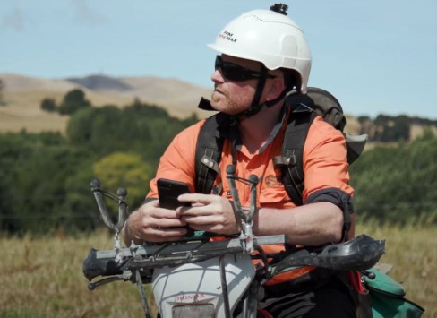
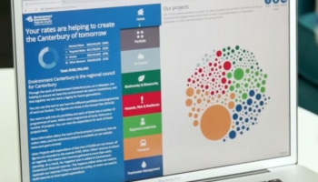
Environment Canterbury partnered with Orbica to create an online tool, opening up their rating data to engage with the public and show how funds are spent in the community.
Published on
WCC Te Papa case study

Serendipity: the hidden value of open data

Te Papa has used Wellington City Council's freely available cyber twin of Wellington City so museum visitors can explore the impact of tsunamis.
Published on
Image of woman's face overlaid with binary code.

Open source software release saves nearly $1m

The Social Investment Agency and released code for their Social Investment Analytical Layer leading to considerable savings and faster research.
Published on
Screenshot of the localcouncils.govt.nz homepage.

Local councils

Localcouncils.govt.nz presents data from New Zealand’s 78 local authorities, in a consistent format that enables it to be compared and analysed.
Published on
Screenshot: home page of New Zealand Legislation website.

New Zealand Legislation website

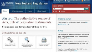
Providing access to legislation is a fundamental part of the PCO’s role – and in 2008 they launched the New Zealand Legislation website. The site provides free access to legislation, including up-to-date reprints of Acts and Legislative Instruments.
Published on
Screenshot from the Register showing annual returns for a charity.

Charities Register

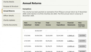
In 2011 Charities Services (then the Charities Commission) made advanced search functionality available for the Charities Register and licensed the data for re-use under a Creative Commons BY licence.
Published on
Screenshot showing map of Christchurch with sample values and options.

Affordability in NZ

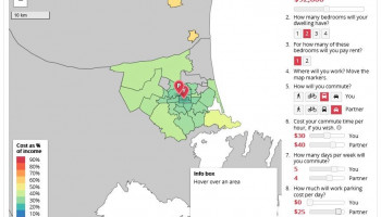
This open source web application uses open government data and a mapping interface to enable people to find out which suburbs will be most affordable for them.
Published on
craft beer 1

Craft Beer Industry Insights

The ANZ Bank uses open data to create craft beer industry insight reports that inform investment, enable evidence-based business decision making and foster consumer loyalty.
Published on
Screenshot of LINZ map with markers that can be clicked to show information.

NZ tides prediction data

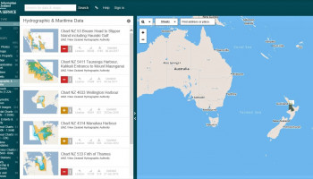
LINZ is provides charts and hydrographic services producing specialised nautical charts to aid safe navigation in New Zealand waters and certain areas of Antarctica and the South West Pacific.
Published on
data govt nz blog

Thundermaps - Staying safe from hazards around you

An app that aims to make workplaces safer by showing nearby dangers, so employees can be prepared and keep themselves safe.
Published on
Screenshot of homes.co.nz homepage.

Homes.co.nz - Helping Kiwis make smart property decisions

An online property tool that gives homeowners an easy and free way to search for property data.
Published on
Automated car showing computerised adjustments for ABS, braking and speed.

HERE Maps - The changing face of automotive navigation

In our rapidly changing digital world, new technologies are driving our futures. The next stage in the evolution of the car is driverless cars - and they are just around the corner.
Published on
Screenshot from School Finder. Shows schools in a region and school information.

School Finder

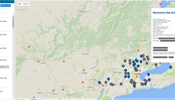
In 2009 The Ministry of Education Te Tāhuhu o te Mātauranga built School Finder – an application that uses Google Maps to present up-to-date information about schools.
Published on
Screenshot of web page map interface showing game preference options.

HuntingSpots

This web tool and app helps hunters and adventurers in New Zealand plan their trips and increases safety.
Published on
Image of fibre optic cables.

Dumpark - Making data and information accessible

Turning data into visual narratives to share and help people understand complex information.
Published on
Image of paper circles.

Open source licence guidance for the New Zealand Government through public participation

Valuable guidance on the licensing and release of publicly funded software as open source (publicly accessible and legally re-usable).The policy is an extension to the popular NZGOAL framework for licensing in government.
Published on
Image of strands of netting.

Kamo Place Race - Town planning made lean and agile

When the Whangarei District Council’s District Planning Team started thinking about a new Town Plan for Kamo, New Zealand, they wanted to make it meaningful to the people most affected – the people who live there.
Published on
Abstract image of points of light.

ANZ Truckometer

Using the volume of traffic on state highways as an indicator of the momentum of our economy
Published on
Image of light.

DigitalNZ - Making it easy to find New Zealand’s digital treasures

Finding material online can be a complicated and confusing process, especially when looking for New Zealand content. DigitalNZ provides one simple place to access this type of content.
Published on
Photo of trees reflected in water.

LAWA - Connecting with New Zealand’s environment through data

Land, Air, Water Aotearoa (LAWA) is a collaboration of organisations with a common aim: to tell the story of our environment.
Published on
Blurred image of greenery.

Nest Finder - Accessing essential travel information while on the road

When tourists are travelling around New Zealand, there is a vast amount of information they need to access including where to stay and what to see. This is where the handy Nest Finder app comes in.
Published on
Abstract image of paint.

State of the Nation - Telling a different story about the nation

The Salvation Army has published its independent monitoring report, ‘State of the Nation’, for the past eight years. This aims to encourage public debate around New Zealand’s social progress.
Published on
Screenshot of hydrographic images in LINZ Data Service.

LINZ Data Service

LINZ Data Service (LDS) holds more than 40 groupings of data on New Zealand’s land and sea.
Published on
Screenshot of the industry benchmarking tool homepage on the Inland Revenue website.

Industry Benchmarking Tool

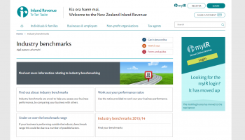
The Industry Benchmarking Tool is a joint initiative between Statistics NZ and Inland Revenue to provide information on the financial performance of businesses in 45 industries.
Published on
Screenshots of MarineMate app.

MarineMate app

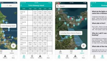
The app contains: Tide timetables using the Nautical Almanac from Land Information NZ, Boat ramps, 5 knot zones, mooring zones, etc from each council Notices to Mariners from each council and from Land Information NZ, Bylaws from each council.
Published on
Screenshot of PositioNZ homepage.

PositioNZ GNSS Data

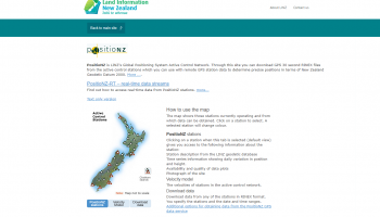
LINZ releases two forms of GNSS data from the PositioNZ network; static data and real-time data. The static data is used by surveyors to determine accurate positions once they have returned from the field, a technique called post-processing.
Published on
Screenshot of the Mogeo homepage, featuring the NZ Fishing Rules app.

Mogeo

Mogeo, an app development company based in Christchurch, creates mobile application solutions to business delivery problems clients have identified.
Published on
Screenshot of ECan's open public transport data homepage.

Environment Canterbury Public Transport Open Data

In May 2005, Environment Canterbury began releasing public transport data for re-use. The data includes route details, bus stop locations, scheduling details, as well as the real time bus estimated time of arrivals (ETAs).
Published on
data govt nz blog

Wellington City Council Geospatial Open Data

In April 2010, WCC began licensing and releasing geospatial data for re-use. This includes aerial photos, historic maps, boundaries, contour lines, building footprints, utility networks, hazard information and locations of WCC facilities.
Published on
Screenshot of the Land Cover Database homepage.

Land Cover Database

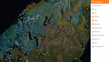
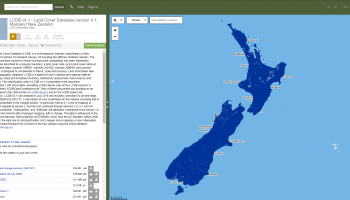
The Land Cover Database (LCDB), available to users of the Land Resource Information System (LRIS) portal offers environment data held by Landcare Research for re-use in GIS and mapping applications.
Published on
Screenshot of the GeoNet homepage.

GeoNet

GeoNet provide free access to high quality and timely data and information for emergency management, research, industry use and to the public.
Published on
Screenshot of the InfoConnect homepage.

InfoConnect

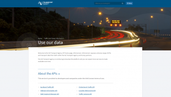
InfoConnect is an NZTA initiative to help ensure road users have access to timely and accurate road condition information.The ultimate aim of InfoConnect is to help empower road users to make their own travel choices and decisions.
Published on
Screenshot of CamperMate homepage.

Campermate

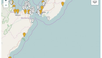
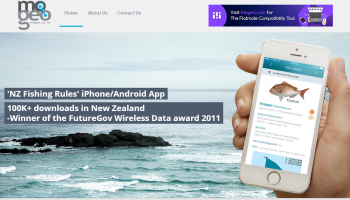
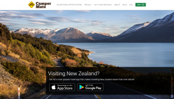
CamperMate is a smart phone application created by a company called Mogeo, and is available at www.campermate.co.nz providing information about local facilities to campers/travellers throughout New Zealand.
Published on
Screenshot of the Infoshare homepage.

Infoshare

Infoshare, a self-service open online data tool on Stats NZ’s website, contains over 30 million aggregated, confidentialised, time-series data.
Published on
Screenshot of the Tier 1 statistics homepage on the Stats NZ website.

Official statistics

Tier 1 statistics are New Zealand’s most important statistics, and are essential to help the Government, business, and members of the public to make informed decisions and monitor the state and progress of New Zealand.
Published on
Screenshot of the 2006 Census homepage.

2006 Census

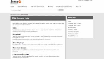
The census is one of New Zealand’s most important data sources. Statistics NZ released aggregated, confidentialised data from the 2006 Census including information on age, ethnicity, income, workplace, dwelling size and other variables.
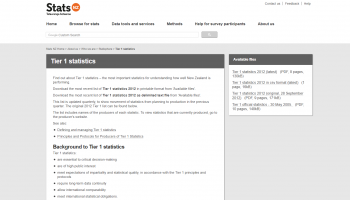
Published on
Screenshot of the economic indicators homepage on the Stats NZ website.

Economic indicators

Economic indicators data is regularly released by Statistics NZ. Most of these indicators are updated on a quarterly and annual basis.
Published on
Top